Monday, December 23, 2013

Salher-Salota, Mulher-Mora - Trek

Ever since I heard about the highest fort in Maharashtra, Salher, and saw the pictures of the impressive mountain, I've been making plans to visit Salher and it's satellite fort of Salota. I came across a group that had organized a 2 days and 3 nights trek that also included Mulher and Mora and immediately decided to board the ship.

Salher, Salota, Mulher, and Mora belong to the Baglan region of Sahyadris. This area has experienced vibrant and intense moments in history. The famous Battle of Salher (1671-72 AD) took place near Salher fort. This major battle was probably the only battle that Shivaji fought on open ground against the Mughals. (Most of his battles involved sneaking up on the enemy and taking them by surprise.) The forts do have remnants of their original splendour albeit in a dilapidated manner. If you allow your imagination to soar, you can build up a splendid and vivid picture of what these forts would have been in their glory. I wish our leaders or institutes would have spent some money to maintain such monuments from the past.

Day 0 - Pune-Waghambe
We started from Pune to Waghambe village that is just before Salherwadi, the base village for Salher fort. The journey was quite long and we reached at around 7:30 AM at the base. After a quick breakfast, we started the climb for Salher.

Day 1 - Salher-Salota
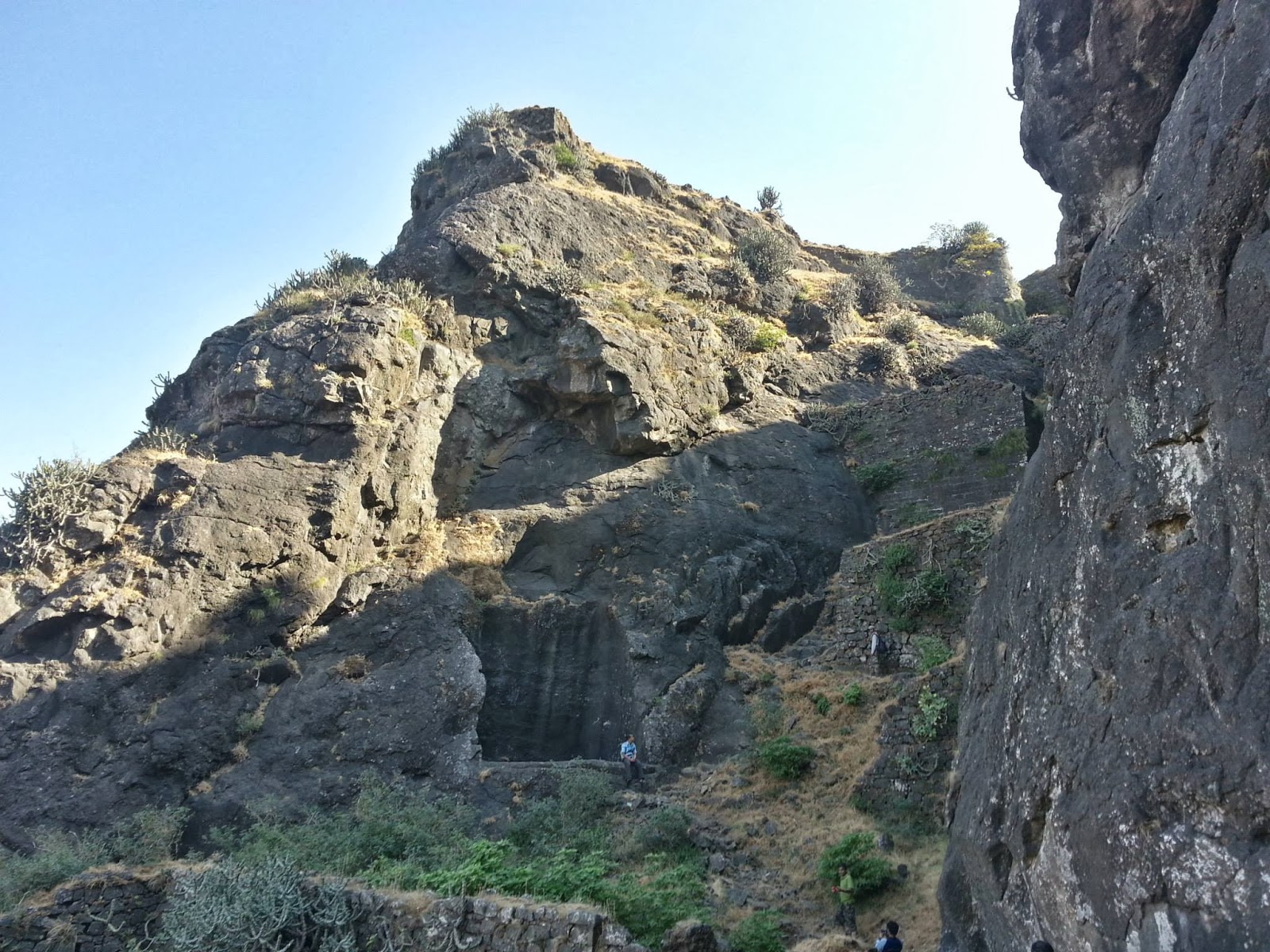
The plan was to climb Salher and Salota and reach the Waghambe village by evening. We started at around 9:30 AM for Salher. The climb though not difficult, is on a continous incline.
Salher fort from Salherwadi
The route throughout has several doors or gateways. Some of them are really impressive. There are some steps on the way cut in stone.
You can see the incline
After reaching a plateau, we walked along till the main caves on Salher. The caves are big enough to fit almost 20-30 people. From the caves, we started our walk to the highest point on Salher, the Parshuram temple.
Towards the Parshuram Temple
From here, we see the Baglan range. We could also spot Mulher-Mora and Hargad. We could also spot Salota that is connected to Salher.
Nearest mountain is Salota
It's difficult to guess the way that takes you up Salota. It seems as if it's cleverly disguised. After spending some time near the Parshuram temple, we started climbing towards the ridge that connects Salher and Salota. This walk was the best part of the trek.
Salota on the left while traversing Salher
Traversing around Salher, looking at the steep valley below, walking along endless water cisterns and caves, sometimes walking under overhanging rock, and continuously looking towards the beckoning Salota.
Salher to Salota - route map
While exiting Salher towards the connecting ridge, there is another door that leads to steps down to the ridge. Walking across the ridge, we looking for a road towards Salota. This is another traverse around till the point of stone-cut steps. We managed to get lost and after asking a shepherd, we got back on track.
Onwards the ridge to Salota
Salota is steeper and more challenging than Salher. All along the traverse, there is a valley on one side while you are continuously climbing. Even the steps are high.
Salota and it's rock-cut steps
After reaching the top of Salota, we were amazed how similar Salher looks to that of salota from afar. It's almost a pyramid in shape.
Salher as seen from Salota
There are water tanks on top of both Salher and Salota and if you carry Medichlor, you can be relaxed about the availability of water. The vegetation is sparse around and because of the continuous shining sun, you are bound to be thirsty and so do not worry about water.

From the top of Salota, we again descended to the ridge connecting Salher-Salota and from this point, we started walking towards the base village of Waghambe. It was quite a long walk and by the time we reached the village, we had to use torches as it became dark after sunset. At Waghambe village, our bus was waiting to take us to Mulherwadi, the base village for Mulher, where we planned to stay overnight. We stayed in an ashram overnight and ate at a locals place.

Day 2 - Mulher-Mora
After an early morning breakfast, we resumed day 2 of our trek. I was worried that the long walk and climb that we did for Salher and Salota would cause some muscle ache on Day 2, but the deep overnight sleep and limbering up done in the morning sun proved to be rather good.

Mulher trek starts from Mulherwadi. All along the trek, we could see the steep peaks of Mangi - Tungi right opposite Mulher.

After the initial walk traversing around the fort through shrubs and grasses, we reach the beautiful Ganesh temple.
Ganesh temple en route Mulher. Hargad in the background.
From here, the route towards the east takes you to Mulher while the western route takes you to Hargad. After a while we came across another water tank called “Moti tank”. There is a story that Shivaji dumped some of his loot from Surat in this water tank to lessen his load. There is a big tank nearby that is called “Hatti (elephant) tank.”

The climb towards the top of Mulher is across a beautiful route that goes zig-zag between walls built to stop the enemy.
It is incredible to see the old structures standing the test of time and nature. Then again, you can stop and wonder about the erstwhile original structure and be completely impressed.
Reaching the top of Mulher
I loved the climb on Mulher more than the climb on Salher. It was a lot more impressive in terms of beauty but not as difficult.
Mulher on left, Mora on right - route map
The tricky part was the connecting ridge between Mulher and Mora. While it was not as long as that between Salher and Salota, it was quite tricky in terms of the slope and the deep valley on one side. Mora can be climbed from the ridge via a stone-cut steps leading towards a door.
The stone steps leading to the top of Mora
There are no structures on top of Mora and after spending a little time, we descended as we had to resume our journey to Pune.

This was a memorable trek, and very different from the nearby ranges in Pune. The mountains in the Baglan region are steep and most of them have a prominent cliff peaking on top. I’ll remember this most for the wonderful traverses that were challenging for the body and mind.

Monday, December 16, 2013

Kulang trek - Camping on the edge of the Kalsubai range

Ever since my earlier trek to Kalsubai and Ratangad, and after looking at the magnificient trio of Alang-Madan-Kulang (AMK), I kept yearning for a trek to Kulang. Kulang is the easier of the trio, but it is also the highest climb in Maharashtra. Imagine the joy that I felt when I found out that a trekking group was planning an overnight trek to Kulang in the cool month of December!

The trek began overnight on Friday. A bus was arranged for a serious group of 10 people. We started at around 11:30 pm and after an event-filled night that included a tyre puncture at around 1:00/2:00 am, no sleep because of the bumpy route, driver acting cranky because of the long route, et al, we managed to reach Ambewadi/Ambevadi village at 5:30 am.

Sleep was out of question for me. I was just glad that we reached a place where I could see the mountains.

Some people from our group managed some sleep in that short time while the rest of us roamed about. The plan was to take a break of about an hour and then have tea-breakfast and move to Kurangwadi / Kulangwadi from where the route to Kulang trek starts. We took the help of a local villager to show us the route as it could be confusing at times. There are ways that villagers use to take their cattle for grazing that are misleading.
Kulang trek begins.
The route initially takes you along some small farms, Kolhapur-type dams, eventually leading to the base of the mountain and the start of the incline. The walk is continuously upwards almost at an angle of 40-45 degrees.

After almost 90 minutes we reach a rocky patch that has footholds in the rocks that are remnants of steps. The angle of inclination slightly increases here and for a long time we climb along the rocky patches. Along these patches, we collected fallen twigs a wooden sticks that we intended to use as firewood. It's better to collect them in the last two-thirds of the climb because once the rock patches start, it's difficult to find any firewood. There are no trees on the top of Kulang.
Eventually, we come near a stone staircase which probably got saved from the British canons because of the height from the base. This staircase is remarkable and you keep wondering how the people from the yore would have managed to reach till this point and then use tools to cut through the stone.
That slight opening in the rock face are the stairs.
After climbing the staircase, we finally reached on the top of Kulang. It took us about 2 hours 52 minutes to climb. This is probably a good time according to one of our instructors since it included a couple of breaks as well.
From Kurangwadi to the top of Kulang (click to see the larger version)
On the top of Kulang we settled in a cave. The cave is big enough to accommodate 20-30 people. We were just 10 so it proved to be rather big for us.
The cave
After settling down for a while, we started preparing lunch. It was indeed a fun time to make a rustic stove made up of stones and use firewood as fuel. We also visited the water tanks (about 7-8 in number) that are on the east of the cave and used them for cleaning up the dishes. There is one particular tank that has cleaner water and we could see the bottom of the water tank. We used water from this tank for drinking (after treating it with Mediclor!) Lunch as usual was splendid for the hungry appetites and the sleep that followed was blissful.
Some water tanks
What woke us up after the afternoon siesta was a slight chill in the air, mostly because of the drop in the temperature of the cave floor. The silence inside the cave was deafening. No external sound at all! This was around 5 PM. A plan was made to walk towards the edge eastern of Kulang from where we could see Madangad, Alang, and the unmistakable peak of Kalsubai. It probably is the highest point on Kulang and a splendid place to catch the sunset from.
The first peak on the left is Kalsubai. The immediate peak in the front is Madangad.
We walked back to the caves in that twilight time and then settled outside the cave for some soup and dinner. Then we met another small trekking group that had climbed after us. Some of these guys had a tent and others were planning to sleep outside in the open. This was a very inviting idea and I always like to test my sleeping bag so I was all for it! What an experience it was to sleep outside in the open, where the wind chilled our senses and the innumerable stars shined upon our eyes, while the moon smiled in it's glorious crescent.
Our camp site facing the entrance to the caves. (morning time)
Though I did wake up whenever the wind managed to sneak inside my sleeping bag, it was indeed a splendid idea to sleep out in the open. I just had to lift myself slightly towards the east and I saw the hint of the rising sun. What a peaceful morning time it was!
Shades of the morning
Then after the usual morning activities and watching the sunrise and basking in its warmth, we decided to break our fast, pack our bags and start our journey back. While others were packing up, we decided to visit the western end of Kulang. The view from this part of the mountain was beautiful. We could see the ranges all in their morning glory (though under a net of haze) and were amazed at the magnificent beauty.
We could have easily spent a lot of time watching these mountains and the surrounding scenery. The edge becomes sharper towards the flag and the subtle thrill that walk gave is difficult to describe.
Top of Kulang showing the relative location of caves and water tanks. The green marker is the location of the flag.
The downward journey was swifter as expected, but we managed to get lost because we did not have anyone to show us the route. But this was just once and after asking the few villagers, who had climbed to collect firewood, we managed to reach the base, cook lunch, find our bus, and start our return journey to Pune.

Kulang indeed is a beautiful trek. Best time for the trek would definitely be just after monsoon when the grass is green yet the sky is open and the surrounding ranges are visible. It is so serenely peaceful on the top, that I thought of planning a stay for a week sometime. Think about it, collect firewood, cook food, read, sleep, roam around.

In peace!

Wednesday, November 27, 2013

Kalsubai - Ratangad: Two treks

Winter season arrived with a chill. Along with it came the thoughts of escaping the Pune region and its neighbourhood Sahyadris and venture northwards. Mainly towards the Igatpuri and Nashik regions. Many avid trekkers have waxed eloquent about the mountains in this area, and particularly those around the Bhandardara dam.

On one particular Thursday I got to know that a local trekking group is about to go on a Kalsubai (highest peak in Maharashtra) and Ratangad (One of Shivaji's favourite forts) double trek. They were to leave on the very next day i.e. Friday. The usual thrill to plan and make it happen in such a short time was enthralling. Friday afternoon I booked my berth on that evenings bus along with the fellow trekkers! Fortunately, it was a small group of 10 people. Less noise and more maturity! ;)

Pune - Shendi - Baari - Kalsubai
We started on Friday night at around 11:30 PM. The plan was to reach Baari village, the base of Kalsubai and the starting point of one of the best known routes, in about 5-6 hours and rest wherever we could before starting the trek. What with nobody knowing the exact route and the over-confidant driver enacting as if he is driving a sports car, and the curvy mountain roads, we landed in another village called Shendi. Shendi is slightly towards south of Baari (about 10-15 km). At roughly 5:00/5:30 AM, we just parked the bus in what looked like the village square and slept in the bus. An hour or so later, we woke up, had tea breakfast and after finding about the exact route to Baari, moved on.

Before reaching Baari/Bari, there is a board near Pendshet that announces the easiest route to Kalsubai (This was nowhere mentioned on any blogs so we were sceptical). The local villagers from Baari later told us that this was just a political ploy by the administrators or the villagers from Pendshet. So, if you do go, avoid that route.

After reaching Baari we got set and began the trek. Kalsubai, even though the highest peak in Maharashtra, is not the highest climb. The route continuously ascends but is not difficult.
Trek begins towards the Kalsubai peak hidden behind a cloud.
At around 30% mark, there are metal ladders along the path. While some of them are rickety, they do not seem that dangerous!
Some of us thought that we should reach the top after we climb the ladders, but that was just 50% of the route. More walking!
Beyond ladders. Kalsubai is the second peak from the left.
Towards the end, there another long ladder that takes you the highest point where the Kalsubai temple is located. This place is filled with people resting after the long trek. There were some refreshments and I gulped down two glasses of Taak / Chaas made from the local buffalo's milk. I also opened up Harish Kapadia's wonderful book "Trek the Sahyadris" and tried to point the several mountains based on the neat maps from the book. The weather was a bit foggy and some of the mountains were partially hidden.
Range around Kalsubai
After waiting for a while, we started our journey back and had lunch en route before boarding the bus.
Route from Bari/Baari to Kalsubai peak
Baari - Shendi - Bhandardara Dam - Ratanwadi
From Baari, our bus took us back to Shendi, and then via Bhandardara dam, we reached that quaint little village called Ratanwadi. Ratanwadi is know for Amruteshwar Mandir. I was really impressed by the clean village.
Amruteshwar Mandir, Ratanwadi
We loitered around Amruteshwar Mandir and the village and then had the usual fare of local poli-bhaaji-varan-bhaat dinner served by one of the locals. That dinner was the amazingly satisfying for our tired body and minds. Since we were a small group, we decided to sleep in the verandah of a local house. The same kind people who had served us dinner and were going to be our hosts.

Early morning on the second day, we started moving towards Ratangad. It is a scenic route that takes you along a brook, forests and then another set of ladders.
This definitely is one of the beautiful trekking routes I've come across so far. It's pleasing to the eye, shades you from the sun, and broadcasts the lovely sounds of birds.

On reaching the ladders, you'll see that there are stone cut steps as well besides the ladders.
Ladder on the left, steps on the right.
After climbing the ladders, we directly went to the Nedhe (Eye of the Needle) and rested there, surrendering ourselves to the surrounding splendid panorama. From the Nedhe you have a commandeering view of the Bhandardara dam region. Must be a good spot for the soldiers to scout.
After spending some time and gulping some food, we started back. Completing our double trek.
Ratangad route via Ratanwadi

Monday, November 25, 2013

Shivaji: In search of an English Biography

With the recent Sahyadri treks and the associated staccato, disordered reading of the history of the Shivaji and his conquests from the web, I realized that I need to pick up a good non-fiction book that accounts Shivaji and his victories. Finding one in English was not an easy task. Here are the popular biographies of Shivaji in English:
  • The History of Mahrattas by James Grant Duff (Published in 1826) - Shivaji's story is a part of this book.
  • Shivaji and his times by Sir Jadunath Sarkar (Published in 1919) - This is one of the famous versions and is still quite easily available in the market. This book is described as "hypercritical in method and sceptical in its intellectual outlook" and "His (Sarkar's) sympathies are anywhere except with Shivaji and his gallant companions" by N. S. Takakhav in an introduction to his version of Shivaji's life.
  • The Life of Shivaji Maharaj by N. S. Takakhav (Published in 1921) - This is adapted from a Marathi book written by K. A. Keluskar. This book is not easily available, but it does seem exhaustive.
  • Shivaji: the story of the great king by Charles Augustus Kincaid (Published in 1950) - This version not exhaustive and a bit orthodox.

Friday, October 4, 2013

A Cool, Dark Place by Supriya Dravid - Book Review

"All these words turned out to be wretched custodians of memory. They cut me to the core and taught me that absences have a presence too."
-
Don, the Mother, Gravy, Zephyr, Sancho, Robert, the Banker, et al. The characters in this book are as eccentric as they come. Some, specially Don. Scratch that, just Don. Larger than life. Almost like making a peg of whiskey that is too much for the poor glass to handle. The glass is not half-empty or half-full in this case, but overfull.

After a turn of events, Zephyr comes across these poignant cobwebs in her family history that trap her. And guess who the liquor-loving Spiderman is? As the pages turn, new information is revealed to Z and from then on, there is a downward spiral. If there can be further downward movement when one is already down.

She gets to know about her wild grandmother, her effervescent mother, and the other puppets in Don, her grandfather's, kingdom. How he pulls the strings, how he jokes, and how he plays with their memories is A Cool, Dark Place.

Somewhere one doesn't need to go, but is already present, in the recesses of their minds.

The language used in the book is beautiful. There are some phrases that are too much to handle, but I guess there are moments in life that make you think of ghastly atrocities too. Language is just an outreach. I would definitely recommend this book to people I know who'd appreciate the dark poetry that this book is.

It's like drinking a fine, yet eccentric single malt whiskey.
-
“How often do we tell our own life story? How often do we adjust, embellish, make sly cuts? And the longer life goes on, the fewer are those around to challenge our account, to remind us that our life is not our life, merely the story we have told about our life. Told to others, but-mainly-to ourselves.” - Julian Barnes, The Sense of an Ending (My review here.)
-
A Cool, Dark Place has these strong flavours that remind me of another story. I know the exact story that the book reminds me of, but putting it as "another story" serves as a temporary respite.
-
A Cool, Dark Place is that intensely flavoured dish that you like from your favourite eating place that one day has been slightly overdone. All the flavours have been magnified such that individual flavours stand out and overpower the other, yet each sustains it's own battle.
-
Don Draper, after being divorced from Megan lost the custody of his boy to Betty. After a lot of convincing and legal power play, he managed to be a custodian and guardian to the effervescent Sally, his daughter.

Don moved to India, Madras to be more specific, started a leather business and resumed his love for the life-saving brown fluids and power. More like dissolving his life in alcohol one peg at a time. Just like the way specimens are preserved in a biological laboratory. It's tough to figure out how Don eventually turns out to be, but that's life.

A Cool, Dark Place could very well be a story of Don Draper's fall and rise just like the bubbles trapped in a champagne bottle falling from the bottle in the champagne flute and escaping from there.
-
“History is that certainty produced at the point where the imperfections of memory meet the inadequacies of documentation.” - Julian Barnes, The Sense of an Ending
-
For an actual (and good) review of the book, check here.

Wednesday, September 25, 2013

Purandar Trek

I had visited Purandar sometime last year and thought of visiting Purandar along with the neighbour Vajragad in this monsoon season. So, we started early morning at around 6 AM   keeping in mind that we have to trek two forts. We decided to trek Purandar first and then Vajragad.

Imagine our surprise and disappointment after climbing up Purandar (by 7 AM) halfway till the motor road stops and finding out that the Indian Army has taken over Vajragad entirely, and you cannot visit Purandar before 9 am. You are just not allowed to climb beyond the motorable road. There is a check post built there where you have to register your details.

What to do till 9 am? Specially when we found that Vajragad is totally out-of-bounds? Ate Poha at Raja Canteen, spoke to the owner of the canteen about changes that are happening, some grapevine stuff he had heard about the reason behind the increase in security, and click pictures.

But then, when we finally made the climb and walked towards Kedareshwar temple, completely forgot about the trivial nature of the temporary feelings and submitted ourselves to the immense beauty of the lovely environments and it's elements.

Getting back to the facts, we reached Narayanpur via NH-4 (took a left at Kapurhol), parked at the base of the fort and climbed up via Bini/Binny/Binni Darwaja. You can also take your cars up till Bini Darwaja, park your vehicles midway, and climb the rest bit of Purandar.
Bini Darwaja
The best part of Purandar, as with most other forts, is the connecting ridges on top. Strewn with lovely little wild flowers, enchanting you with a lovely play under sun and shade, hiding in clouds, beckoning you to go further and surrender to nature.
As you walk away from Vajragad, you go to the Balekilla (which we didn't climb) and further to Kedareshwar temple. There are these beautiful steps just at the base of the temple that look majestic. The view from the temple is scenic.

We kept wondering how scarily beautiful it would be to stay in the temple at night staring at the starry night, enveloped in clouds swayed by wind, and artificial lights staring at us from afar like animal eyes.
You can see the Kedareshwar temple left of centre in the picture.
Kedareshwar temple was the highlight of this trek.

So much for the Indian Army!

Tuesday, September 17, 2013

Tikona - Tung Trek

Tung on the left, Tikona on the right.
Tikona is a friendly trek. It is a really good choice for a beginner or someone who wants to do a leisure trek. But what makes this trek superb is the scenic surroundings. Located besides Pavana Lake, Tikona (the name translates roughly to triangular) gives a splendid view across the lake where you can see Tung fort and Lohagad - Visapur forts at a distance.
Lohagad - Visapur as seen from Tung.
Tikona is strewn with yellow flowers called Bristly Smithia that makes the climb heavenly.
Bristly Smithia. You can see the Tung peak in the background.
We had done Tikona earlier and knew that it is not that strenuous a trek so thought of adding Tung to it. The plan was to drive to the base village called of Tikona called Tikona Peth (via Mulshi - Pirangut - Paud) do a quick Tikona trek and then drive down to Tung (via Javan) and climb from the base village called Tung Wadi. The right turn to Tung Wadi is a little confusing. Better to keep checking with the local folks.

Tung does look formidable from Tikona, but as you see it from the side, it looks assailable. The route up is quick but steep with an ascent all along the route. The stony, barely-visible route does add to the adventurous charm. I believe Tung is not that visited by trekkers.
Slightly hidden route.
This time around with the receding monsoon, we had to do the trek under proper sunny conditions. From the past experiences where we were blanketed by think fog or clouds with intermittent rains, the sunny, hot, and humid environment ensured that we kept sipping water every other time. But the conditions helped to get excellent pictures. We had started around 7:00 in the morning and by 1/1:30 pm we were done with both the forts.

Then, the usual haunt of butter chicken! :)

The special feeling of climbing Tikona and looking at Tung and then climbing Tung and looking at Tikona was splendid. These are the moments that make us plan a trek almost every other weekend.

Thursday, September 12, 2013

Joy in the Morning by P.G. Wodehouse - Book Review

Joy in the Morning (Jeeves, #8)Joy in the Morning by P.G. Wodehouse
My rating: 5 of 5 stars

To summarize the book, "It's a confounding concatenation of comic circumstances."

The unassailable melodic ring of that entire line is rendered ineffective by the fact that someone decided to pronounce circumstances as "sircum" and not "kircum". To summarize my feeling after realizing that, I would gently employ the Puneri word "Shyeah".

Joy in the Morning is one of the best horses from the PGW Turf Club. I strongly suspect that it would win or come second only to the ablest of contenders Right Ho, Jeeves in a royal derby decided by the degrees of concatenating circumstances.

It is also splendid to see all the little digs taken at several authors like Hemingway, Shakespeare, and also that rather humorous chap called Wodehouse.

Truly a joy!

View all my reviews

Thursday, August 29, 2013

Jealousy, envy, and use-and-throw paper cups

I was wondering how the word "jealous" is thrown around easily like it's a use-and-throw paper cup. "feeling resentment against someone because of that person's rivalry, success, advantages, etc." Then again, resentment is "the feeling of displeasure or indignation at some act, remark, person, etc., regarded as causing injury or insult."

Isn't that too strong a feeling to be used casually? Or have we come to this stage?

Or is it used instead of Envy "a longing to possess something awarded to or achieved by another?"

Envy is not a word that was associated with a certain (and now mostly non-existent) Onida TV.

The quoted definitions have been taken from www.dictionary.com.

Tuesday, August 27, 2013

Visapur Trek

From the time we had been to Lohagad, Visapur was always on our mind. Maybe because we had heard that it is a little challenging than Lohagad (thus attracts less public) or maybe just because we had come so close to it that it had decided to pull us back to the summit.

So Visapur was planned a jiffy, and as usual we hunted for the best possible climbing route. Since we were already familiar with Malavli from our previous Lohagad trek, and the fact that there is ample parking at the base village Bhaje, we decided to drive down.

A valuable tip for any Sahyadri trek is to start as early as possible. In the monsoon, with overcast conditions you don’t need to worry about the Sun, but you can easily avoid the hordes that start climbing late. That feeling that you have climbed up, spent adequate and peaceful time on the summit, and encountering folks who are climbing up when you descend is rather good! Especially when you meet like a hundred, noisy, hormonally-driven kids who are climbing up after you've had the fort summit to yourself is just sublime!

Oh, but I digress. Just the way we had lost our route on the way up Visapur!

After parking at Bhaje and eating sumptuous breakfast, we started the climb to the Bhaje caves.
Bhaje caves
After looking at the Bhaje caves for 15-20 mins, we started the climb towards Visapur summit. You can find an interesting map for the various Visapur trek routes on this blog.
Visapur is on the left, Lohagad on the Right
Our route was a slight modification of the route that goes via Bhaje caves. If you look at the map, we took Route no i), and went along till we saw a summit but started traversing it towards Route no iii).
From the various blog posts, I had read that when you are going via this route, there are chances of getting lost in the forest. It is mainly because there are many pathways created by grazing animals and they appear as proper walking trails. The main tip everyone suggested was that take the route that ascends. After walking for a while when our route started descending a bit and we came across a densely covered path, we decided to go back to the place where we had seen some huts and ask for the right route. Fortunately, after walking back for some distance we came across a group who were climbing up and had taken a local guide to help them find a route. This chap took us right near the summit. If you see the map where Route no i) goes close to the fort, is the place we climbed up. A little tricky, but thrilling route!
On reaching the top, it was the usual lovely weather where wind played with the clouds and all the natural elements lifted our happy spirits even more. The green landscape was strewn with lovely little white, pink, and purple flowers. We saw a few broken structures as well. There are numerous water tanks on Visapur.
While climbing down, as suggested by the local guide who had accompanied the other group, we found Route iii) (from the map) and started climbing down. This route was along a waterfall or should I say that it intermingled with the waterfall for about 20-25 minutes. There were broken steps and stones carried down by the waterfall. It was a bit tricky going down this route.
After a while, there is a detour where we had to leave the waterfall and traverse across the fort. Here we met about a 100 people climbing up!

On reaching the base, we got in the car and went straight to Hotel Siddhi and had an amazing lunch.
-
Lohagad and Visapur can be done in a day, but it’s better to keep them separate as each has its own charm. And try and go on a Saturday, especially if you are a small group, as a large number of people come here on Sundays.