The year 2013 was the year of mountains and it was fitting that 2014 began with a trek that is considered to be one of the most exhausting yet enthralling treks in the Sahyadris.
Harishchandragad is a mystique mountain. With roots creeping long back in history and the presence of various magnificent ancient artefacts, the alluring magnetism of this mountain is completely justified. It is also not surprising that because of the huge base of the mountain, there are several routes leading to the top. Villagers from the villages scattered around use their own routes as per the closest available option. In the monsoon we had used the very comfortable
Pachnai / Paachnai route to climb Harishchandragad. Nalichi Vaat is in a different league altogether. So much so that we did descend via Pachnai route and it took just about 12% of the total trekking time.
The entire experience during the trek was so overwhelming that I still cannot fathom the right words to describe it. That moment when I saw the silhouette of the Konkan Kada at night from the village of Walhivale, realizing how grand it was when the early light of the day elucidated it further, the climb towards the Kada, the left towards the path between two cliffs (ghali), the boulders, rocks, stones, talus, and scree along the route, the relief-laced ecstasy felt on the top of the Kada, just cannot be fit into the right words. Same goes for the lovely stay on the top of Konkan Kada in tents, the lovely group that had a fun time over a camp fire, the descent via the familiar Pachnai route, realizing that it was just a small part of the way back, seeing the impressive Sadhale Ghat, thanking the Lord that we have to walk down and not climb via Sadhale Ghat, realizing again that it is just as painful and exhausting in different ways, and finally making it to the village and coming back to Pune.
Even if I jot down some hasty words right now, I get a feeling that the impact of the words would be ephemeral. To a certain degree, this is true even about the pictures. I hope the combination of these two would help me travel through time to the memories of the beautiful trek.
Before I begin the short photo-log, I would like to add this note I had written for my Facebook Nalichi Vaat album:
Some mountains keep calling you back. This one, after engulfing us in mist and fog earlier this monsoon, beckoned us for a strenuous climb via the route known as Nalichi Vaat. This route begins in front of Konkan Kada, detours along the left side of it and then concludes on top of the Konkan Kada. The surface changes from big boulders along a dry river bed, to smaller stones on a steep ascent, to talus and scree, to manageable rock faces, and finally through friendly shrubs. While walking down, we descended via the lovely Pachnai route and then circumvented Harishchandragad via a route called Sadhale Ghat. It was Nalichi Vaat without the difficult part, but very similar. A lovely trek that enthrals and frightens at the same time, whispering to you that you are but a spectator in this big world.
Photo-log: Walhivale to Harishchandragad via Nalichi Vaat
Driving till Walhivale. Crossing Khubi Phata, crossing Malshej Ghat and then taking a right ahead of Moroshi. As easy as it sounds, it was a different experience altogether in the night. Single winding road, no street lights, no village in immediate line of sight, and not so obvious road signs.
 |
| Walhivale village route via Khubi Phata, Malshej Ghat, and Moroshi |
After a spending the night in the quaint (oft used word describing the base villages in Sahyadris, I guess!) village of Walhivale, we woke up early morning to see the hazy splendour of the Konkan Kada.
 |
| Konkan Kada from Walhivale |
Starting the walk towards the Konkan Kada. The path is strewn with boulders and almost-dried water channels. We start walking directly towards the massif of Konkan Kada.
After walking quite a bit, the route moves towards the left of Konkan Kada and finally we see the Nalichi Vaat and the "Ghal". You can see from the picture how massive it looks. Looking at these pictures, it all seems so unreal now.
 |
| Towards the Ghal in Nalichi Vaat |
As we turn left, this is the view of Konkan Kada. The sun had started to rise up lighting parts of Harishchandragad.
 |
| Konkan Kada on the left |
More play of sunlight as our strenuous climb went on and on...
 |
| Spot the fellow trekker |
... and on and on...
... and on and on through talus...
... and scree...
... and a few rock patches en route. Ropes are essential for some of the rock patches. The good part is that there is no direct exposure to the valley, but we have to take utmost care. All throughout.
Finally completing... about 1/3rd of the route.
And then we saw the glorious Konkan Kada from a bit close. The rest of the route was getting on top of the Konkan Kada.
 |
| Just about there on top of Konkan Kada. |
The following picture is the route map from Walhivale to the top of Konkan Kada via Nalichi Vaat. Total distance was approximately 8.03 km, and total time taken was 6 hours 35 minutes.
 |
| Walhivale to Harishchandragad through Nalichi Vaat |
Photo-log: Harishchandragad to Walhivale via Pachnai and Sadhale Ghat
After camping on top of Konkan Kada and spending a lovely camping night, we started descending via the Pachnai route. It was lovely to see it again, clearly this time, without the haze and mist.
 |
| Pachani route in the Winter |
 |
| Almost the same location that was captured in the Monsoon earlier this year |
After Pachnai, we had to circumvent Harishchandragad using a plain, drivable road, and then through a little forest till we reached Sadhale Ghat. After a long and hard walk, with the remnants of the pain from Nalichi Vat still significantly present, we started descending...
... all the while I was well aware of the bone structure in my knees, and was getting more aware of it with every single step...
... and after a rather long walk down and then through relatively knee-friendly plain grounds, we reached the village of Walhivale.
 |
| Konkan Kada as seen from the village of Walhivale |
The following pictures is the route map from the top of Harishchandragad via Pachnai and then Sadhale Ghat. Total distance was approximately 11.72 km, and total time taken was 5 hours 20 minutes.
 |
| Harischandragad to Walhivale via Pachnai and then Sadhale Ghat |
"So, are you ready to do this trek again?"
Am I?
 After walking quite a bit, the route moves towards the left of Konkan Kada and finally we see the Nalichi Vaat and the "Ghal". You can see from the picture how massive it looks. Looking at these pictures, it all seems so unreal now.
 ... and on and on through talus...
 ... and scree...
 ... and a few rock patches en route. Ropes are essential for some of the rock patches. The good part is that there is no direct exposure to the valley, but we have to take utmost care. All throughout.
 Finally completing... about 1/3rd of the route.
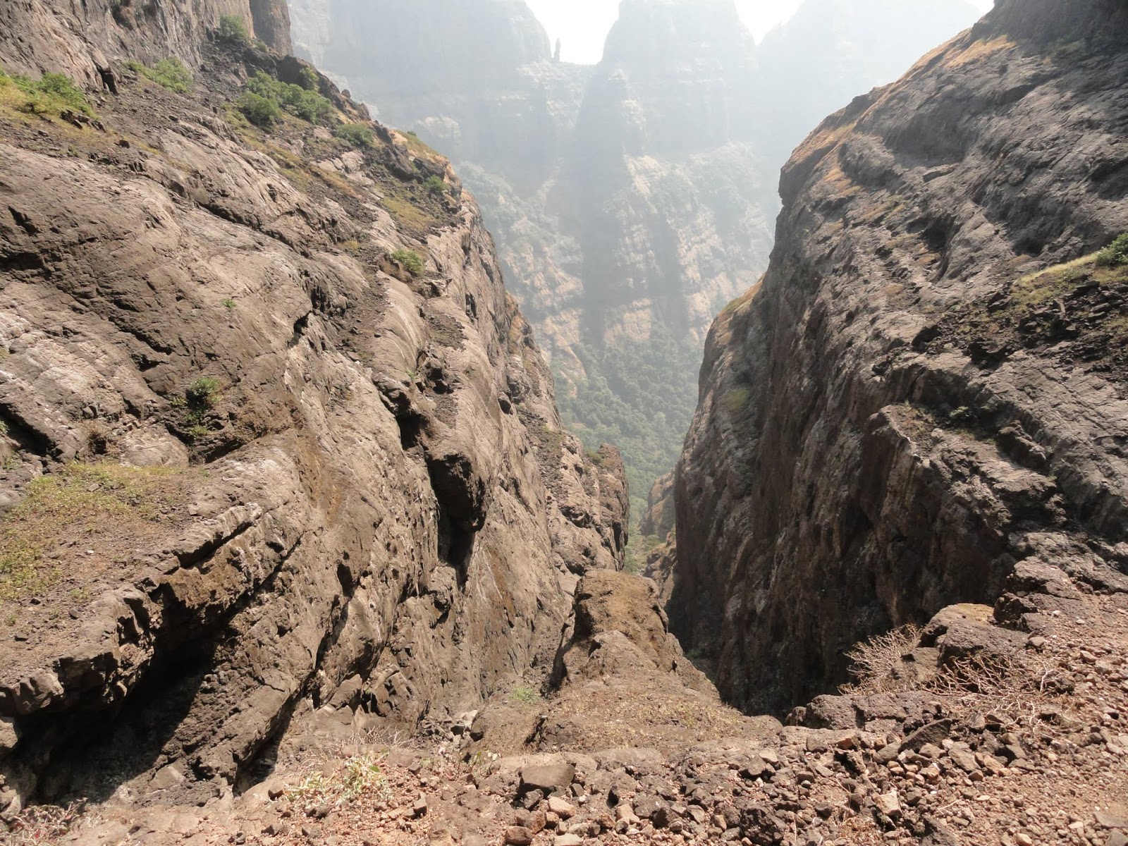 And then we saw the glorious Konkan Kada from a bit close. The rest of the route was getting on top of the Konkan Kada.
 ... all the while I was well aware of the bone structure in my knees, and was getting more aware of it with every single step...
 ... and after a rather long walk down and then through relatively knee-friendly plain grounds, we reached the village of Walhivale.
No comments:
Post a Comment